
IAAC – Institute for Advanced Architecture of Catalonia
Global Summer School Program 2025
Online Course: Synchronous & Asynchronous Agenda.
Duration: 21st July – 25th July 2025
GSS25 URBAN DATA ANALYTICS
Image Based Analytics for Data Driven Mapping of Urban Vulnerabilities
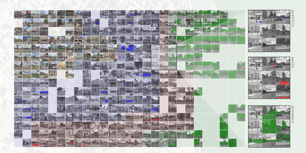
Image: Data mapping of multiple StreetView image retrieval and analysis in the city of Bogotá. By Juan C. Giraldo
Syllabus
Key topics: Urban Data Visualisation & Mapping, Data Analytics, Data Driven Design, Urban Data, Computer Vision, Image Segmentation, GIS Integration
The implications of the image of a city, or the urban qualities embedded in visual form, although not new to urban studies, have become more and more relevant mechanisms to determine behavioural occupation in today’s digital urban age. With the growing proliferation of computer vision and image processing techniques, streetscapes are now recognized as valuable urban data sources. Traditionally, large-scale spatial data analysis has allowed us to explore the relational qualities of urban datasets and visualize non-visible urban conditions; now, ground-level perspectives offer insights into the actor-object dynamics within the city, indexing urban qualities through visual data.
In this workshop, we will explore the potential of constructing urban analyses from multiscalar datasets, specifically street view imagery and GIS. We will quantify quality using Google Street View (GSV)—for example, measuring the percentage of street level visual contamination—and qualify quantity through GIS data—for example, overlapping tax revenue census data with street waste disposal systems.
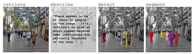
Image: Image-based Analysis over a StreetView image of Barcelona through LLM models. By Juan C. Giraldo
Google Street View has become a fundamental research tool in built environment studies, providing data on greenery, transportation, socio-economic conditions, perceptions of safety, gentrification, and walkability. During this workshop we will investigate what these types of datasets can reveal about a city’s overall health. If buildings can suffer from Sick Building Syndrome (SBS), could cities experience a similar phenomenon? SBS has been linked to poor ventilation, inadequate maintenance, and suboptimal construction materials, often linked to health concerns. Could we conceptualize an equivalent “Sick City Syndrome,” where urban dysfunctions, due to inadequate infrastructure, environmental degradation, or governance failures, lead to systemic harm to its inhabitants?
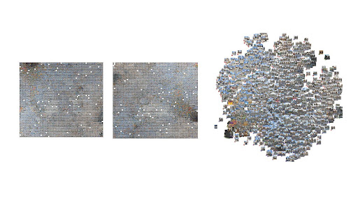
Image: Panoramic Vision: Computational Streetscape Analysis is a project of IAAC developed in the Master in Advanced Urban Planning & Data Analytics (previously City & Technology) – 2023-2024 by the students Pruethicheth Lert-udompruksa, Siddharth Nambiar, Sharon Megan Wong and Soham Bhanushali during the course MaCT01 23/24 Computational Urban Design III with Iacopo Neri and Eugenio Bettucchi.
Using the cases of Bogotá (Colombia) and Barcelona (Spain) this summer school will develop new methodologies to assess urban space quality and uncover hidden urban conditions through four modules—Data Collection, Data Analysis, Data Mapping, and Data Showcasing—using both ground-level and large-scale datasets.
During the workshop there will also be contributions on behalf of Dr. Mathilde Marengo, on Spatial Justice and Data Driven Methodologies: Creative and Critical Actions; Iacopo Neri, on Urban Visual Studies: Multimodal investigations with Deep Learning Foundation Models; Ana Gallego on Data visualization; and Laura Guimarães on Data storytelling.
Learning objectives
At course completion the student will:
- To understand the potential applications of combining computer vision techniques and GIS tools in urban analytics.
- To explore the implications and possibilities of building multiscalar datasets to investigate urban vulnerabilities, examining how varying levels of data granularity can reveal critical insights.
- To develop critical and analytical skills for mapping complex urban realities.
- To investigate urban data visualization workflows, reflecting on how different data processing and visualization techniques can be integrated to better communicate urban
Previous Knowledge / Students background requirements
The workshop is open to all applicants with a bachelor degree (or in progress) in any field related to Architecture, Design, Social Sciences, Arts and Engineering. Any skills and understanding of QGIS tools, Google Colab, and Adobe Photoshop is welcome.
Faculty

Valeria Ospital Greslebin is an architect from Universidad Torcuato Di Tella in Buenos Aires. She holds an MS in Design Theory and Pedagogy from SCI-Arc, and was an Assistant Teacher at Studio Lynn in Universität für angewandte Kunst in Vienna. Prior to this, Valeria taught at Di Tella in core and thesis studios, as well as aesthetics seminars. She was also involved in SCI-Arc’s research department’s project on developing alternative ways of measuring displacement pressures in Los Angeles. She has collaborated with the CEAC (Center for Contemporary Architecture Studies) and was editor and contributor to SCI-Arc’s Offramp 18. Her research interests revolve around the use of software as a policy-making tool and harnessing qualitative and quantitative data to inform urban transformation projects.

Juan Camilo Giraldo is an architect and civil engineer from Universidad de los Andes in Bogotá, Colombia. He is currently pursuing a “Master’s in City and Technology ll” program at the Institute of Advanced Architecture of Catalonia (IAAC). He has worked as a transport planner for projects in several cities across Latin America, focusing on public transport modeling, pedestrian mobility, and environmental assessment of public transport projects. He was also part of the UN-Habitat City Resilience Global Programme, where he contributed to automating a pipeline for retrieving and analyzing urban and territorial indicators from cities worldwide. His research interests revolve around the integration of innovative data sources, GIS, machine learning, vision, and large language models (LLMs) for human-centered analyses of urban and territorial phenomena.
Lecturers

Head of Studies / USL Director / MUPD (formerly MaCT) Co-Director (she/her)
Mathilde Marengo is an Australian – French – Italian PhD Architect whose research focuses on enabling spatial justice in cities by leveraging advanced technologies to bridge data gaps and enable designers and decision makers to leverage these and integrate the perspectives of all, both humans and more than humans, into urban planning towards the development of evidence based, inclusive and just urban futures.
She is Head of Studies, Faculty and PhD Supervisor at the Institute for Advanced Architecture of Catalonia (IAAC) researching, designing and experimenting with innovative educational formats based on holistic, multi-disciplinary and multi-scalar design approaches, redefining the paradigm of design education within the context of the climate crisis, rapid technological development and planetary urbanisation.
At IAAC, she also directs the Urban Sciences Lab (USL), a research group that enhances the creative practice of urban design through data driven methodologies. The USL explores urban design intelligence within the contexts of urban ecologies and regenerative landscapes; urban communities and public space; and urban analytics and spatial justice pioneering the transition of the urban environment in the era of big data. As part of her work in the USL, she Co-Directs IAAC’s Master in Advanced Urban Planning & Data Analytics.
Her investigation is also actuated through her role in several National and EU funded research projects, as well as being published and exhibited internationally.
Iacopo Neri (he/him) is the Master in City & Technology’s Urban Computation Lead, his research situated at the intersection between architecture, computer science and urban planning. He holds a Master of Science in Architecture with Distinction at The Polytechnic University of Milan, and attended a Master in City and Technology at the Institute for Advanced Architecture of Catalonia (IAAC, Spain) after presenting a paper about Swarm Intelligences for crowd-based analysis during the Responsive Cities Symposium (2017, Barcelona). He has been involved as a teaching assistant since 2015 at the University of Florence, later, at The Polytechnic University of Milan, and finally at IAAC where he is currently part of the City and Technology computational research team. He also works as a computational designer at External Reference Architecture Bureau, Barcelona.
Weekly Schedule & Time Table
Option 1 – Synchronous calendar (Barcelona time – GMT+2)
Recommend to European, African, Asian and Australian participants.
From Monday 21st July – Friday 25th July 2025
Teaching activities will run from 10.00 to 14.00 GMT+2
– 8 hrs of live teaching
– 8 hrs of live mentoring and exercises review
– 1 hr of IAAC summer lecture
– Final GSS diploma certificate ceremony
Option 2 – Asynchronous calendar (America time – GMT-4)
Solution recommended to participants from all the time zones who are looking for a more flexible schedule.
From Monday 21st July – Friday 25th July 2025
Live teaching activities will run from 11.00 am to 1.00 pm (GMT-4)
– 8 hrs of recorded teaching
– 8 hrs of live mentoring and exercises review
– 1 hr of IAAC summer lecture
– Final live GSS diploma certificate ceremony
Workshop schedule
A tentative schedule of the Week 1 following the GMT+2 (Barcelona time) format:

Main tools
Students need to use their laptop and a list of installable links will be sent a few days before the program starts.